 |
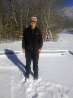
| Snow at 4,400 ft |
When planning the year 2013 I had wondered what to do after the Mississippi. It seemed frivolous to fly to the US and only spend 3 months there. But it would be winter at the end of my paddling trip and options for winter excursions where pretty limited. But for many years I had wanted to hike the some shorter trails in Southeastern US: The Pinhoti Trail and the Benton MacKaye in Alabama, Georgia and Tennessee. And although these states are not Florida, the winter in the Southeast is not extreme either. So a plan formed: I had always wanted to do an extended winter hiking trip. I had done several week long winter trips in Germany, but nothing longer than 8 days. I did not want to experience Arctic conditions but was looking for a moderate winter climate. Southeast US seemed perfect for two reasons: The average minimum temperatures hover only around freezing even in the middle of winter. Of course there could be an unexpected arctic blast, but most likely I would encounter sub freezing temps only at night. Serious snow should only be an issue at higher altitudes and the further South I would hike the less chance of snow. But the most striking argument was the amount of daylight. Even around Christmas I would have 10 hours of daylight. Add dusk and dawn and I would have almost 11 hours of daylight for hiking!
I was sold and decided to look at this trip as a learning experience. I realised that this would not be the most comfortable or easiest trip I have done. This would be a trip to test my limits. How long can I endure adverse weather without seriously suffering. How would my equipment fare? What sort of new experiences would I have and what skills would I learn? I started this trip curious and a bit frightened, but keen to see where it would take me.
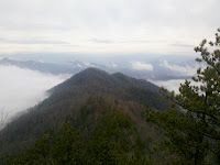 |
| Rare view on the AT |
The plan was to hike get to the AT first because it was easiest logistically. The AT also had the highest altitude of this trip and I wanted to get this out of the way before the weather got seriously bad. Reluctantly I decided to skip the Smoky Mountains. They were too high and I did not have enough time before flying back. The risk of getting stuck in the snow there was simply too great. I had less time than expected and as I had thruhiked the AT before it did not matter to me where I would get on it. Franklin dropped me off at Neel's Gap at mile 30 of the AT. I would hike north on the AT for 130 miles to get to Fontana Dam at mile 161 and change onto the Benton MacKaye Trail (BMT).
 |
| Cascade on the Pinhoti |
The BMT is the AT's little know brother. It was created to relieve pressure from the AT. It is far less hiked than the AT though and has only two shelters. Like the AT it starts at Springer mountain, but ends at the Northern end of the Smokies at Davenport Gap. Between these two points the two trails form a big "8". The upper loop is the shorter one and entirely in the Smokies and I would skip that. I would only do the lower and longer loop south of the Smokies and hike the BMT South until reaching the Northern terminus of the Pinhoti Trail. I would then hike the Pinhoti all the way South until Bull's Gap through Georgia and Alabama. The official end of the Pinhoti is further South at Flagg Mountain, but this involves an almost 30 mile road walk as the trail has not been completed there yet.
The whole trip will be 550 miles to be covered in 5 weeks. This is an ambitious undertaking but there are several options for short cuts or hitching. For me this trip is about testing my winter hiking abilities and I do not care so much about a continuous hike. I just do hope I'll survive....


No comments:
Post a Comment